Summer Photography Weather Guide: Thunderstorms, Haze, and Long Evenings
A practical summer field guide for photographers: chasing storms, beating heat haze, using extended golden hours, and the PhotoWeather rules that help you catch the best light.
Summer Photography Weather Guide: Thunderstorms, Haze, and Long Evenings
Summer gets a bad reputation among landscape photographers. The sun climbs high and harsh by mid-morning. Midday light is flat and washed out. Forests turn into dense green walls with little texture. And heat haze shimmers off every distant ridge, making telephoto landscapes look soft before you even press the shutter.
But summer also gives you things no other season can. The atmosphere is more active. Storms build with real power. Golden hour stretches for hours at high latitudes. The Milky Way core sits high in the southern sky on warm nights. And if you learn to read the signals, summer can be one of the most productive photography seasons of the year.
This guide covers the patterns that matter: thunderstorm dynamics and safety, heat haze and how to work around it, extended evening light in northern regions, Milky Way season timing, dealing with harsh midday sun, and the specific PhotoWeather rules that catch these conditions while you get on with your day.
Why Summer Is Underrated for Photography
Three things make summer special, and they all come down to the same cause: the sun is high, the days are long, and the atmosphere has more energy.
Long days mean more chances. At 60°N, you get over 18 hours of daylight in late June. That does not just mean more shooting time. It means the sun hangs at low angles for extended periods during early morning and late evening, stretching golden hour into something you can actually plan around without rushing.
The atmosphere is unstable. Warm surface air, cold upper air, and strong daytime heating create the convection that powers thunderstorms, towering cumulus, and dramatic cloud buildups. Summer afternoons can go from clear skies to anvil-topped supercells in a few hours.
Milky Way season peaks. From roughly June through August in the Northern Hemisphere, the Galactic Center rises high enough during astronomical night for arch compositions and detailed core shots. You do not need to freeze to photograph it.
The trick is not to treat summer like a worse version of spring or autumn. It is a different season with different rules.
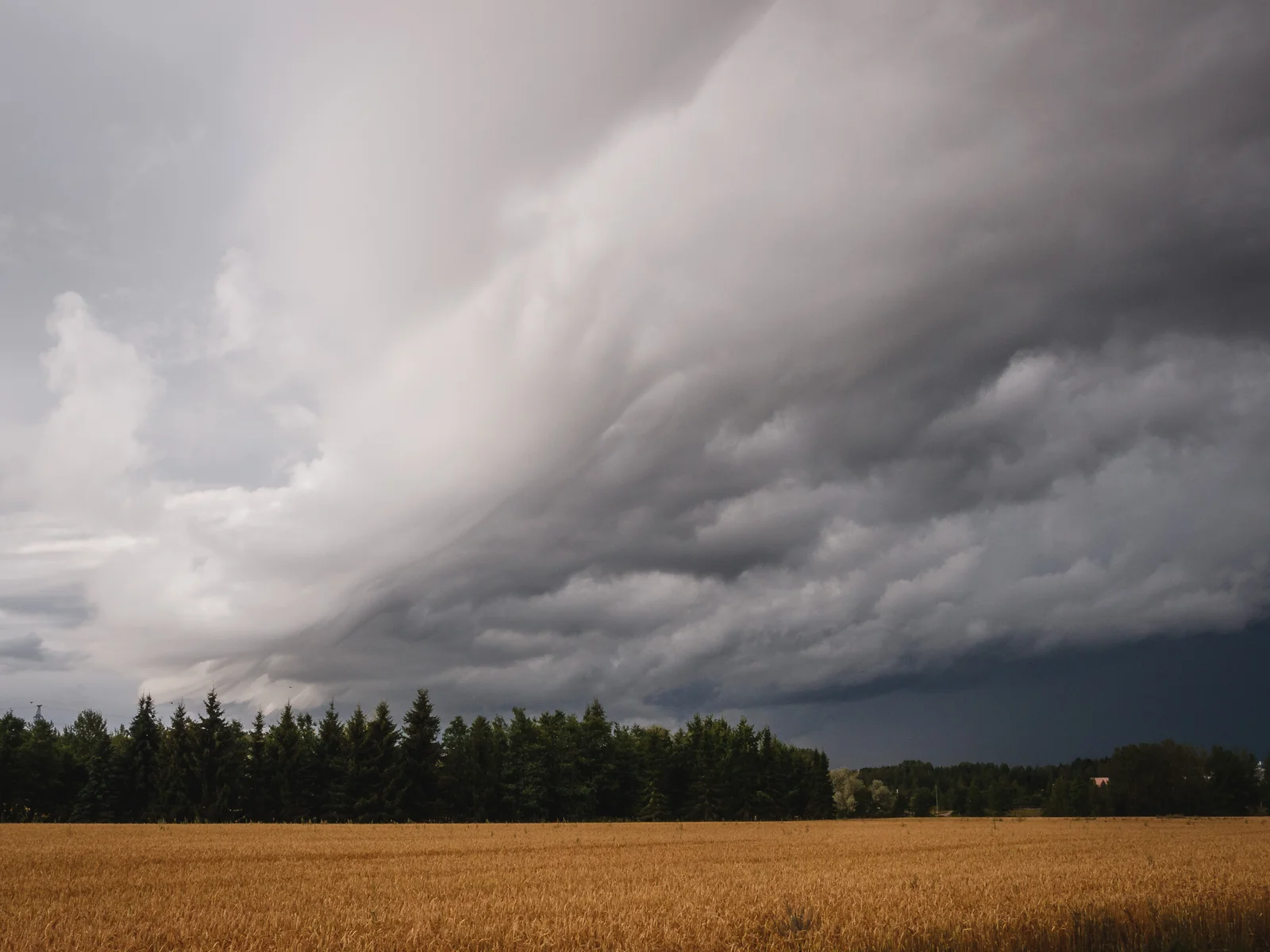
Thunderstorm Photography: Safety First, Then Structure
Summer storms are the most visually dramatic weather events most photographers will ever see. Towering cumulonimbus, shelf clouds, anvil formations, and post-storm light can produce images that are genuinely hard to match in any other season.
They are also dangerous. Lightning, hail, flash flooding, and downburst winds kill photographers every year. The first rule of storm photography is that no photograph is worth your life.
When to chase and when to stay home
Stay home when:
- Wind gusts exceed 22 m/s (80 km/h)
- Hail is forecast
- Visibility drops below 1000 m
- You cannot identify a clear escape route
- Lightning is striking within a few kilometers
Safe chasing practices:
- Shoot from the flank or rear of storms, not underneath them
- Stay in your vehicle during active lightning
- Use telephoto lenses to maintain distance
- Monitor conditions continuously, not just at the start
- Always have an exit route that does not require driving through the storm
Reading the sky before the storm
The best storm photographs usually come from the buildup phase or the clearing phase, not the peak intensity when visibility is zero and lightning is continuous.
Pre-storm buildup is when you see towering cumulus, darkening bases, and defined structure. The atmosphere is organizing. Clouds develop vertical texture. The contrast between bright updrafts and dark precipitation cores creates visual depth.
In PhotoWeather, the Storm Chaser template monitors this buildup using Storm Intensity, Cloud Drama Score, atmospheric instability, and visibility. It is designed to catch organized storms with good structure while filtering out dangerous or visually flat conditions.
For Pro users, the key metrics to watch are:
- CAPE (instability fuel): 1500–2500 J/kg is the sweet spot for dramatic but manageable storms
- Lifted Index below -2°C signals the atmosphere is ready to overturn
- Wind Shear (0-6 km): 10–20 m/s creates organized structure without extreme danger
Post-storm clearing: the real gold
Some of the best summer light happens after the storm passes. Dark cloud masses remain in the background while sunlight breaks through from a low angle. Wet ground reflects light. Visibility improves. And if the timing aligns with golden hour, the result can be extraordinary.
The Clearing Storm template (Pro) is built for this exact transition. It looks for recent rain, current precipitation dropping off, cloud cover breaking up, visibility improving, and sunshine starting to return. It uses trend rules to detect the improving phase rather than just checking current conditions.
If you chase storms in summer, consider splitting your effort:
- Buildup rules for afternoon structure and drama
- Clearing rules for post-storm light in the evening
Both often produce better photographs than the storm at peak intensity.
Heat Haze: The Summer Sharpness Killer
Heat haze is one of the most frustrating summer conditions because it is invisible to the naked eye until you review your images. Distant ridges blur. Long-lens landscapes turn soft. Contrast drops. And there is nothing you can fix in post-processing.
What causes it
Heat haze is caused by temperature gradients in the air. Warm air near the surface rises through cooler air above, creating turbulent refractive index variations that bend light unpredictably. The effect is strongest on hot days with direct sun, especially over dark surfaces like asphalt, rock, or ploughed fields.
It gets worse with:
- High temperatures, especially above 25°C
- Strong surface heating with clear skies
- Long distances between camera and subject
- Telephoto lenses, which magnify the apparent displacement
How to avoid it
Shoot early or late. Heat haze builds through the morning as the ground warms, peaks in early afternoon, and often fades by evening as temperatures equalize. Dawn shoots are usually the sharpest.
Get closer. Haze is a function of the amount of turbulent air the light passes through. Wide-angle scenes with nearby subjects suffer far less than telephoto landscapes of distant mountains.
Seek cooler microclimates. Coastal areas, shaded valleys, and locations near water often have less surface heating and therefore less haze than open inland terrain.
Watch the wind. Moderate wind (3–7 m/s) can mix the air enough to reduce strong temperature gradients. Completely calm hot days are often the worst.
When to use it
Haze is not always the enemy. A little atmospheric softness can improve backlit woodland scenes, layered tree lines, and intimate landscapes where you want separation more than razor-sharp detail. It can also create that characteristic summer glow in wide-angle farm or meadow scenes.
In PhotoWeather, Pro users can monitor Aerosol Optical Depth and visibility to assess atmospheric clarity before heading out. Aerosol Optical Depth below 0.1 indicates excellent clarity. Above 0.3, expect noticeable haze. Combine this with temperature forecasts to identify the days most likely to suffer from heat shimmer.
Extended Golden Hours at High Latitudes
One of summer’s best-kept secrets is how golden hour behaves at high latitudes. In southern Finland, Stockholm, or the Scottish Highlands, the sun barely dips below a low angle in the evening during June and July. The result is not a fleeting 30-minute window. It is an extended period of warm, directional light that can last for two hours or more.
This changes how you plan:
- You have time to move between locations during golden light
- You can wait for cloud positions to shift without missing the window
- You can shoot golden hour portraits or landscapes after a normal workday
- Mist and low haze often persist longer because the sun stays low
At extreme latitudes, you also get the “white nights” phenomenon, where astronomical twilight never fully ends and the sky retains a faint glow all night. This is not ideal for Milky Way photography, but it creates unique twilight conditions for moody landscapes and cityscapes.
The practical approach is to build rules around Golden Hour timing, not fixed clock times. A rule centered on evening golden hour will automatically adapt as the season progresses and sunset times shift. For Pro users, Golden Hour Potential and Golden Clouds Potential add atmospheric quality filtering, so you get alerts only when the sky conditions actually support good light, not just when the sun is at the right angle.
Milky Way Core Season
Summer is prime Milky Way season in the Northern Hemisphere. The Galactic Center is visible from roughly late May through August, peaking in June and July when it reaches its highest elevation during the night.
For Milky Way photography, weather matters as much as astronomy. The core can be perfectly positioned and still invisible under clouds, washed out by moonlight, or softened by haze.
What to watch:
- Astronomical Night: the sun must be more than 18° below the horizon for true darkness
- Moon Phase: new moon is ideal; even a quarter moon can add significant sky glow
- Moon Visibility: the moon being below the horizon during your shooting window is almost as good as new moon
- Cloud Cover: total cloud cover below 20% is the practical threshold
- Visibility: high visibility and low AOD for crisp star detail
In PhotoWeather, the Milky Way Visibility field tracks when the Galactic Center or broader Milky Way band is high enough for quality photography. Combine it with Astronomical Night, low cloud cover, and good visibility for a complete astrophotography rule.
Pro users can also watch Clear Sky Probability (Ensemble) for forecast confidence. A 70% clear probability three days out is worth planning for. A 40% probability means you should stay flexible.
Best summer Milky Way timing
- Core visibility: 20° or higher above the southern horizon
- Peak months: June–July in the Northern Hemisphere
- Best window: typically 11 PM to 3 AM during astronomical night
- Moon strategy: new moon, or moon below horizon during core hours
Dealing with Harsh Midday Light
Summer midday light is hard to avoid. The sun is high, shadows are short, and contrast is brutal. But there are ways to make it work.
Use cloud cover as natural diffusion. A broken cloud layer of 40–70% coverage turns harsh midday sun into usable soft light. The clouds act as a giant softbox, diffusing direct rays while still providing direction and texture. This is one reason summer afternoons with partial cloud can be excellent for forest photography, close-up work, and even portraits.
Seek subjects that thrive in contrast. Graphic architecture, textures, patterns, and backlit scenes can all work in hard light. The problem is not the light itself. It is trying to shoot the same subjects you would shoot at golden hour.
Wait for a cloud to pass over the sun. This sounds basic, but it works. On partly cloudy days, a single cloud can give you 30 seconds of beautiful diffused light. Watch the sky and be ready.
In PhotoWeather, a simple midday rule might look for:
- Cloud cover: 40–75%
- Solar elevation: above 45° (true midday)
- Wind speed: under 5 m/s for stable conditions
- Precipitation probability: under 30%
This catches the afternoons when clouds turn harsh sun into something you can actually use.
Sample PhotoWeather Rules for Summer
These are practical starting points. Adjust thresholds for your local climate, tolerance for false alarms, and how far you are willing to travel.
1. Afternoon Storm Buildup (Pro)
Best for organized thunderstorm structure and dramatic cloud photography.
- Time window: 2 PM – 7 PM (peak convective activity)
- Storm Intensity: 55–75
- Cloud Drama Score: 60+
- CAPE: 1200 J/kg or higher
- Wind Gusts: under 18 m/s
- Visibility: 4 km or better
Start with the built-in Storm Chaser template and tighten or loosen based on your risk tolerance and local storm frequency.
2. Clearing Storm at Sunset (Pro)
Best for post-storm light with dramatic cloud remnants.
- Golden Hour: evening
- Recent precipitation: at least 3 mm in the last 6 hours
- Current precipitation: light or stopped
- Cloud cover: 25–75%
- Sunshine duration: at least 10 minutes in the hour
- Visibility: 5 km or better
- Wind gusts: under 20 m/s
The Clearing Storm template handles the trend detection automatically.
3. Crisp Summer Landscape (Pro)
Best for distant mountain views, telephoto compression, and sharp detail.
- Aerosol Optical Depth (550nm): under 0.15
- Visibility: 15 km or better
- Temperature: under 22°C (to avoid heat haze)
- Wind speed: 2–7 m/s (enough to mix the air, not enough to shake the tripod)
- Cloud cover: 0–40% for clear views, or 40–70% for diffused light
Use this for mornings when you want maximum sharpness and color fidelity.
4. Milky Way Core Night (Free, stronger with Pro)
Best for summer astrophotography during peak core visibility.
- Milky Way Visibility: core
- Astronomical Night: any
- Moon phase: new moon, or moon below horizon
- Total cloud cover: under 20%
- Visibility: 10 km or better
- Wind speed: under 5 m/s for stable tripod work
Pro users can add Ensemble Clear Sky Probability above 70% for higher confidence in the forecast.
5. Soft Midday Cloud Light (Free)
Best for forest interiors, botanical details, and close-up work during summer afternoons.
- Solar elevation: above 45°
- Cloud cover: 40–75%
- Wind speed: under 5 m/s
- Precipitation probability: under 30%
This is a simple rule, but it solves a real problem: giving you something productive to shoot when golden hour is hours away.
A Simple Summer Strategy
If you only set up four summer alerts, make them these:
- Storm Buildup for afternoon drama
- Clearing Storm for post-rain evening light
- Milky Way Core for warm-night astrophotography
- Crisp Morning for sharp landscapes before heat haze builds
That combination covers most of what makes summer special: atmospheric energy, extended light, clear night skies, and the sharpness that only early mornings deliver.
The main thing is to stop waiting for summer to behave like autumn. It will not. The high sun, the haze, and the afternoon storms are the season. Learn to read them, build rules that match how you actually shoot, and let the alerts do the watching while you sleep, work, or plan your next location.
Ready to put summer weather to work for your photography? Add your locations to PhotoWeather and start with the Storm Chaser template if thunderstorms are your target, or the Milky Way Visibility field if warm-night astrophotography is your goal. After your first alert-driven summer shoot, you will have a much better sense of which thresholds match your own terrain and style.